Усовершенствованная многосенсорная всепогодная система точного обнаружения
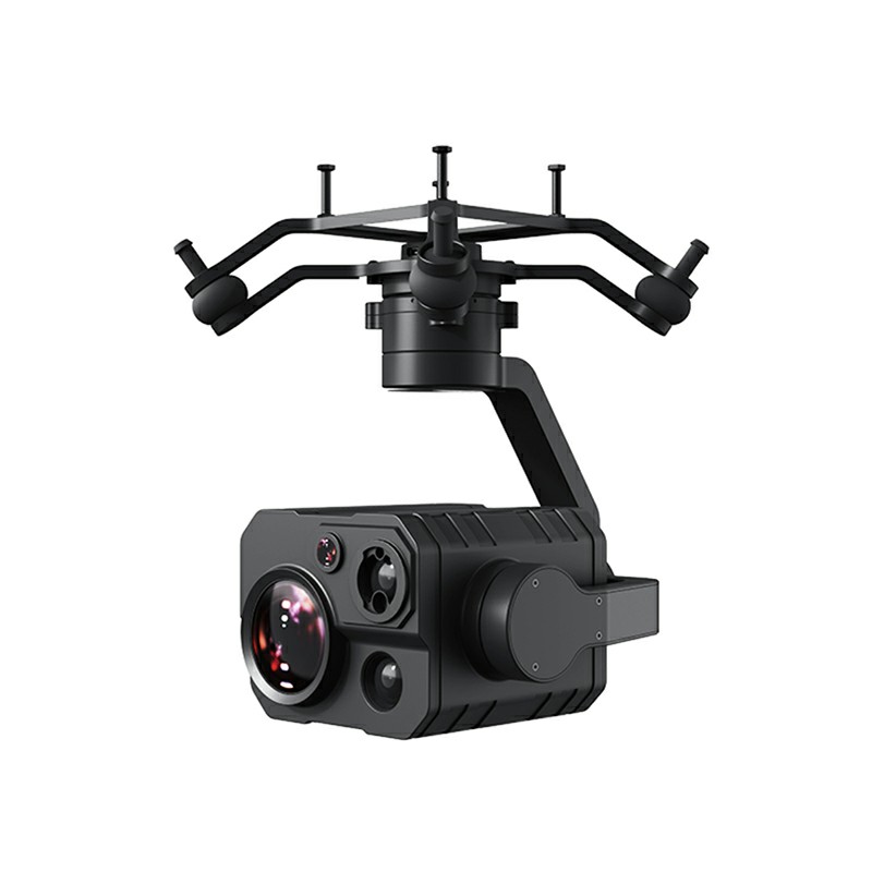

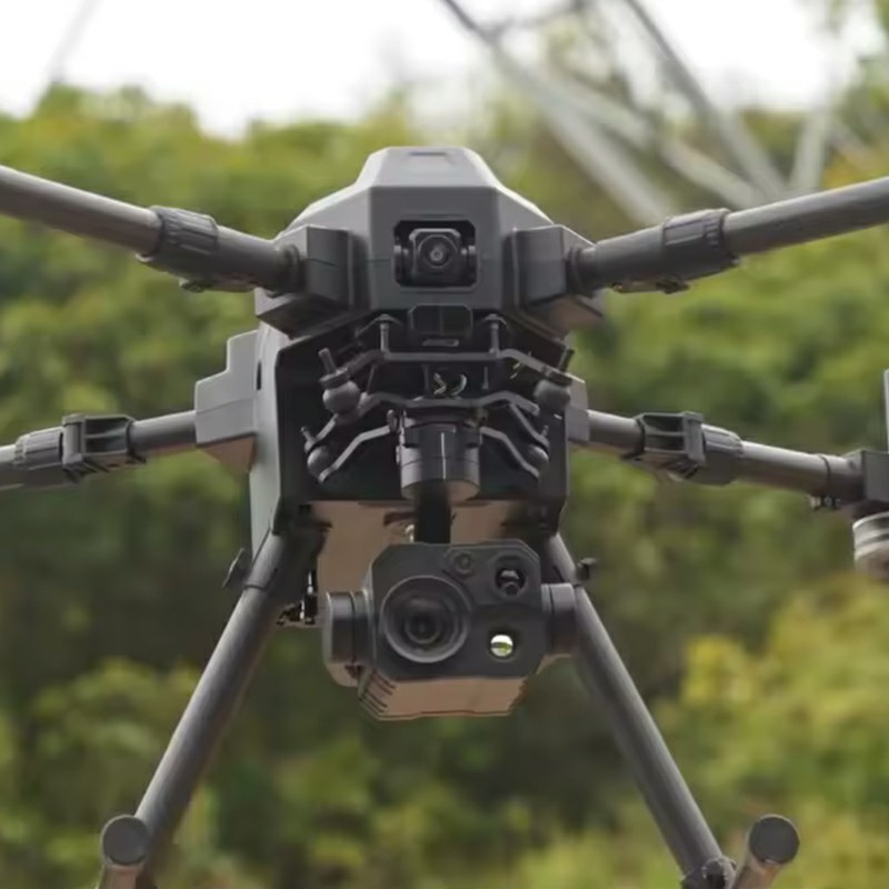

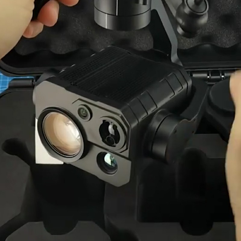

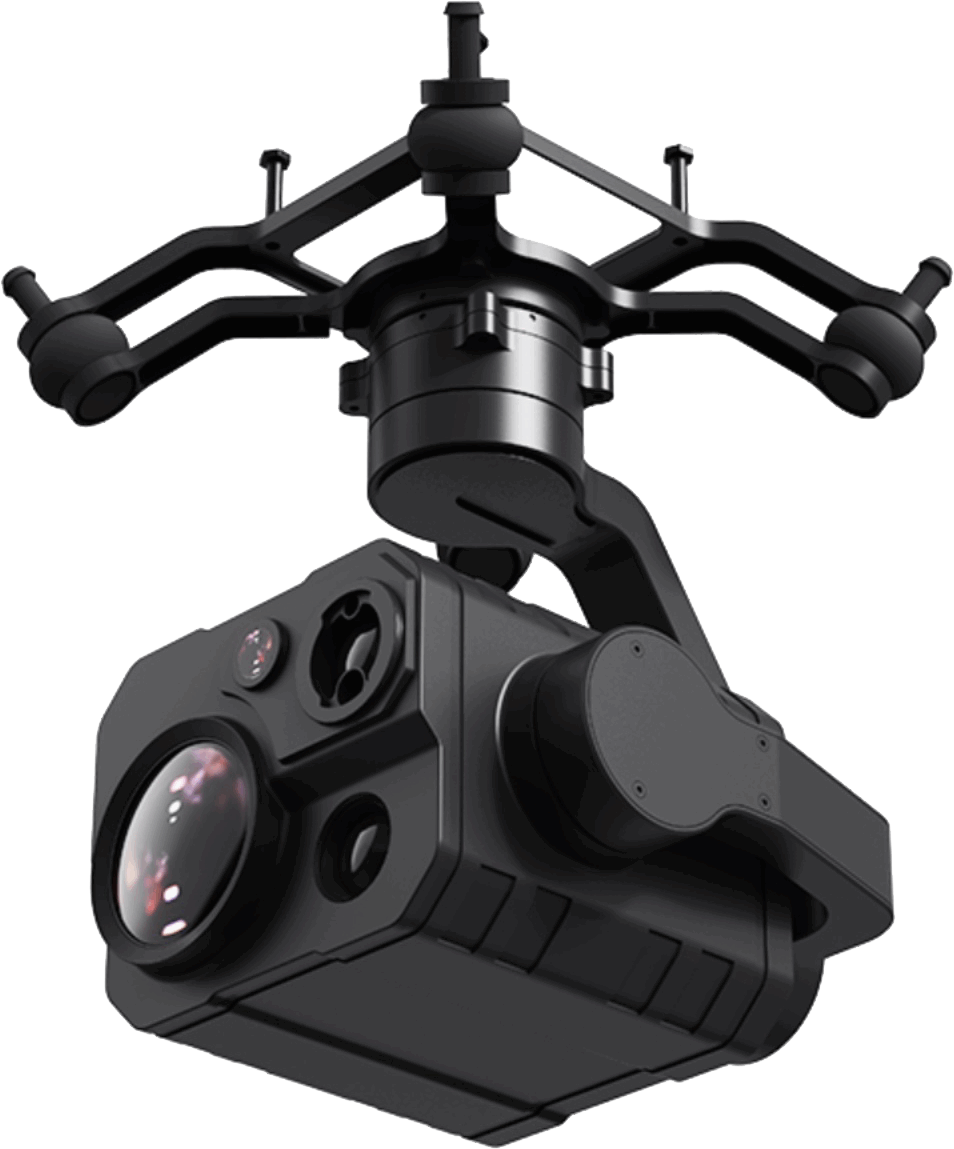


Четырехсветовой модуль LQ-4 объединяет тепловизионные, зум-модули, лазерную локацию и широкоугольные модули, обеспечивая точное обнаружение в любую погоду за счет совместной работы с данными из нескольких источников. Оснащен высокоразрешающей тепловизионной системой и функцией измерения расстояний на больших расстояниях в сочетании с гибридным зумом с высоким увеличением и технологией оптического зума с высоким увеличением, в сочетании с крупногабаритными светочувствительными элементами для поддержки записи изображений сверхвысокой четкости и широкоугольным объективом высокой четкости для расширения поля зрения. Встроенная интеллектуальная алгоритмическая платформа обеспечивает возможность динамического отслеживания цели на основе глубокого обучения, а конструкция глобального вращения оси направления адаптируется к сложным требованиям к рабочему углу. Оптимизация структуры амортизации и модульного интерфейса значительно улучшает адаптивность к окружающей среде, поддерживая расширение и интеграцию нескольких устройств. Благодаря высокоэффективным алгоритмам совместного управления и стабильным системам карданного подвеса он может поддерживать четкое изображение и точное управление в динамических сценах и может широко применяться для требований к монтажу профессионального уровня в таких областях, как винтокрылые самолеты, платформы вертикального взлета и посадки и интеллектуальные мобильные роботы.
Эта система лазерного дальномера с высоким разрешением тепловизионного изображения объединяет четыре усовершенствованных датчика для обеспечения всепогодного восприятия окружающей среды для дронов и роботов. Благодаря динамическому отслеживанию и сверхвысокой четкости изображения она обеспечивает критически важную четкость при пожароспасательных работах, картировании местности и промышленных проверках.
Этот модуль, благодаря органическому сочетанию четырех функциональных модулей, наделяет летную платформу беспрецедентными возможностями восприятия окружающей среды. Его модуль тепловизионной съемки с высоким разрешением использует передовую технологию датчиков в сочетании с широким полем зрения и характеристиками визуализации с высокой частотой кадров, которые по-прежнему могут четко улавливать информацию об источнике тепла ночью или в условиях плохой видимости. Он поддерживает функции глобального сканирования температуры, регионального мониторинга и измерения температуры в фиксированной точке, обеспечивая надежные методы бесконтактного обнаружения для поиска и спасения при пожаре, электротехнического осмотра и других сценариев. Модуль лазерной локации, работающий совместно с ним, имеет сверхбольшую дальность обнаружения и точность на уровне сантиметра, предоставляя точные данные пространственного позиционирования для операторов в операциях с высоким риском, таких как аварийно-спасательные работы и картографирование местности.
Интеллектуальная система визуализации объединяет технологию гибридного зума со сверхвысоким увеличением и оснащена датчиками изображения большого размера, что обеспечивает плавный переход от широкоугольной панорамы к сверхдальнему крупному плану. Модуль оптического зума профессионального уровня в сочетании с алгоритмом фокусировки в реальном времени обеспечивает стабильный и четкий вывод изображения даже в сложных условиях полета. Вспомогательный широкоугольный объектив обеспечивает широкое поле зрения. Благодаря оригинальной технологии сращивания нескольких изображений операторы могут свободно объединять видеопотоки с разных датчиков для достижения синхронного мониторинга ключевого крупного плана цели и окружающей обстановки.
Интеллектуальная система слежения, установленная на устройстве, наделяет капсулу возможностями автономного распознавания и непрерывного слежения с помощью алгоритмов глубокого обучения. После захвата цели система может автоматически регулировать кратность увеличения и угол наклона панорамы, чтобы удерживать цель в центре экрана и поддерживать оптимальное соотношение сторон. Даже после того, как цель ненадолго исчезает, система все равно может быстро выполнить повторный захват, значительно повышая эффективность задач в динамических сценариях. Инновационная функция двойной световой связи позволяет синхронно масштабировать видимые световые и тепловизионные изображения, что позволяет операторам быстро получать ключевую информацию посредством сравнения многоспектральных данных.
С точки зрения механической структуры, он использует конструкцию всенаправленного вращающегося карданного подвеса, преодолевая традиционные механические ограничения и достигая 360-градусного наблюдения без мертвых углов, что особенно подходит для сложного положения полета вертикально взлетающих и приземляющихся самолетов. Модернизированная быстросъемная структура улучшает совместимость оборудования и эффективность установки, а также поддерживает быстрое переключение нескольких нагрузок. Глубокая интеграция интеллектуальной системы амортизации и алгоритма совместного управления гарантирует, что все датчики всегда находятся в оптимальном рабочем состоянии во время полета.
С точки зрения функционального расширения, pod поддерживает аннотацию географической информации и технологию многорежимной фокусировки. Оператор может добиться точного выбора фокуса с помощью сенсорного интерфейса, а функция автоматического слежения за фокусом во время масштабирования обеспечивает постоянную четкость изображения. В ответ на потребности профессионального создания изображений оборудование обеспечивает плавное управление зеркалом и возможности панорамной съемки, отвечая высоким требованиям визуальной презентации, таким как аэрофотосъемка для кино и телевидения и экологическая съемка.
Четырехсенсорный гибрид
Эффективное взаимодействие зум-камер, тепловизионных камер, лазерных дальномеров и широкоугольных камер не только обеспечивает дронам широкое поле зрения, но и позволяет им фокусироваться на поле зрения и получать более четкие изображения, а также обнаруживать источники тепла и измерять расстояния до целей.
Тепловизионное изображение высокого разрешения, измерение глобальной температуры, измерение температуры в фиксированной точке
Оснащенный тепловизионным датчиком высокого разрешения 640 * 512 уровней, дополненным фокусным расстоянием 19 мм и частотой кадров изображения 30 кадров в секунду, он обеспечивает широкое и глубокое поле зрения, плавное и четкое видео, а также позволяет своевременно обнаруживать аномальные источники тепла для визуального бесконтактного измерения температуры с быстрым и точным реагированием.
Высокоточная лазерная локация
Благодаря дальномеру с дальностью действия 1200 метров и высокоточному лазерному дальномеру с точностью 0,1 метра он чувствителен и надежен, способен получать точные указания в режиме реального времени в условиях повышенного риска, помогать в управлении и принятии решений, а также обеспечивать безопасное рабочее пространство.
Технические параметры
общая производительность
|
Интерфейс выходного видеосигнала |
Эфирная сеть |
|
Метод ввода управляющего сигнала |
S.Bus、UART、UDP |
|
Режим вывода управляющего сигнала |
S.Bus |
|
Высокоточная трехосевая стабилизация |
Направление, тангаж, крен |
|
Диапазон рабочего напряжения |
11 ~ 25,2 В |
|
потребление энергии |
Средняя потребляемая мощность 9 Вт, пиковая потребляемая мощность 20 Вт |
|
степень защиты |
IP4X |
|
рабочая температура |
-10℃ ~ 50℃ |
|
Размер продукта |
134,5 * 140 * 201 мм (включая быстросъемные захваты амортизатора) |
|
Вес продукта |
854 г (включая быстросъемные захваты амортизатора) |
|
Размер когтя амортизатора |
140*140*63мм |
|
Вес когтя амортизатора |
104г |
Параметры PTZ
|
Величина углового дрожания |
± 0,01° |
|
Диапазон регулируемого вращения тангажа |
-90° ~ +25° |
|
Диапазон контролируемого горизонтального вращения |
Неограниченное количество позиций |
|
Диапазон вращения валков |
-45° ~ +45° |
Параметры зум-камеры
|
линза |
30-кратный оптический зум (180-кратный гибридный зум) |
|
фокусное расстояние |
4,8 ~ 149 мм (±5%) |
|
датчик изображения |
1/2,7 дюйма, 8 миллионов эффективных пикселей |
|
диафрагма |
F1.3 ~ 4.8 (±5%) |
|
Поле зрения |
Без зума: диагональ 65,4 °, горизонталь 58,1 ° 30-кратный оптический зум: по диагонали 2,48 °, по горизонтали 2,14 ° |
|
Разрешение видеозаписи карты |
4K (4096*2160) при 30 кадрах в секунду 2K (2560*1440) при 30 кадрах в секунду 1080p (1920*1080) при 30 кадрах в секунду 720p (1280* 720) при 30 кадрах в секунду |
|
Разрешение камеры |
4К |
Параметры инфракрасной камеры
|
Тепловизионный датчик |
Микрокалориметрический радиометр на основе неохлаждаемого оксида ванадия (VOx) |
|
разрешение |
640* 512 |
|
ПТЗ |
2-кратный электронный зум |
|
линза |
Фокусное расстояние 19 мм/F1.1 фиксированный фокус без термализации |
|
диапазон длин волн |
8 ~ 14 мкм |
|
Диапазон измерения |
Высокий коэффициент усиления:- 20 ~ +150℃ Низкий коэффициент усиления: 0~+550 ℃ |
|
Точность измерения температуры |
-20 ~ 150℃ (±2℃) 0 ~ 550℃ (±5℃) |
|
Режим измерения температуры |
Глобальное измерение температуры, измерение температуры в фиксированной точке, региональное измерение температуры |
Параметры широкоугольной камеры
|
датчик изображения |
1/2,8 дюйма с 4 миллионами эффективных пикселей |
|
эквивалентное фокусное расстояние |
20 мм |
|
Поле зрения |
Горизонталь 84,5 °, диагональ 93 ° |
|
Разрешение видеозаписи карты |
2K (2560*1440) при 30 кадрах в секунду |
|
Разрешение камеры |
2560*1440 |
Параметры лазерного дальномера
|
Диапазон измерения расстояния |
5 ~ 1200 м |
|
диапазон длин волн |
900 ~ 908 нм |
|
разрешение |
0,1 м |
|
точность измерения |
3 ~ 100 м (±1 м) 100 ~ 600 м (±1 + L*0,25% м, L — расстояние до цели) |
|
Частота лазерного импульса |
3 Гц |
|
Максимальная мощность лазера |
5 мВт |
Другие параметры камеры
|
Битрейт видеохранилища |
15 Мбит/с |
|
Поддержка файловой системы |
FAT32, бывший FAT |
|
Формат файла фотографии |
JPG |
|
формат видеофайла |
МП4 |
|
Поддерживаемые типы карт памяти |
Micro SD class10 поддерживает максимум 128 ГБ |
|
Фоторежим |
одиночный выстрел |
|
баланс белого |
автоматический |
|
Вышеуказанные параметры приведены только для справки. Подробные параметры продукта зависят от фактической поставки. |
|
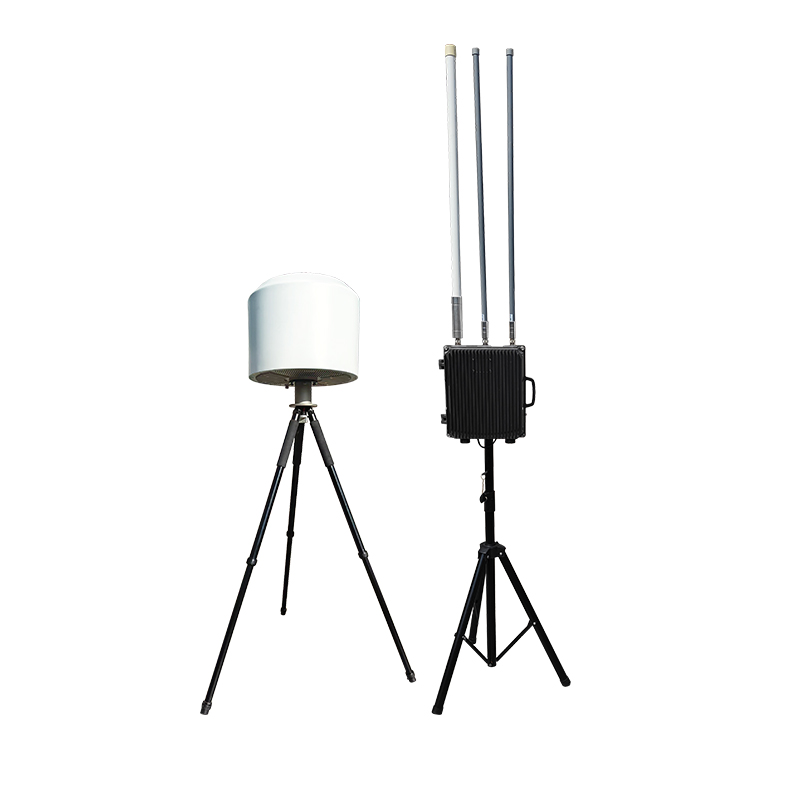
Этот сверхпрочный портативный стенд для запуска дронов обеспечивает грузоподъемность 40 кг и оснащен системой двухканального выброса. Он разработан для устойчивого запуска дронов с фиксированным крылом при боковом ветре. Складная конструкция, соответствующая авиационному стандарту, обеспечивает быструю сборку в полевых условиях и идеально подходит для военных разведывательных и промышленных задач. Ознакомьтесь с техническими характеристиками надежных авиационных решений.
Подробности
Захват для дрона ZS-035 оснащен точным пневматическим приводом, который позволяет захватывать, перемещать, адсорбировать и освобождать объекты в чувствительных и хрупких средах, ограниченном пространстве, условиях неизвестной сложности и т. д. Он водо- и пыленепроницаем, может свободно вращаться и гибко адаптироваться к различным типам дронов. Широко используется в коммунальном хозяйстве, для сбора проб в опасных условиях, для высотных работ, а также при ликвидации последствий стихийных бедствий и спасательных операциях.
Подробности
Этот продукт может использоваться с 60 раствором для точных снарядов, встроенная однонаправленная структура языка блокировки безопасна и солидно и может реализовать операцию по загрузке неэлектрической нагрузки и воздушную нагрузку. Продукт можно использовать со счетом БПЛА выше 3-километровой нагрузки для достижения различных комбинаций номеров каналов и модулей на встроенные целевые и опционные нацеливания и опционные визуальные и опционные.
Подробности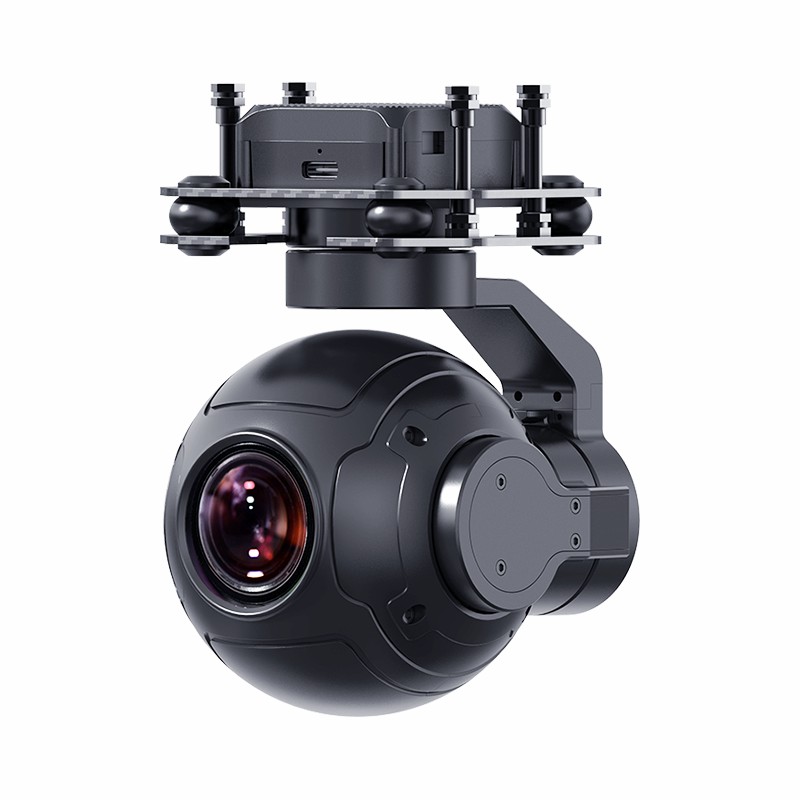
Этот Индустриальная 3-осевая камера беспилотников интегрирует передовые технологии гибридного масштабирования и алгоритмы стабилизации FOC для доставки кристально чистой визуализации даже во время высокоскоростных маневров. Спроектирован для Авиационная проверка и Справочник по безопасности Миссии, его анти-индикационная технология обеспечивает точность на уровне миллиметрового уровня в Высокое картирование приложения. Прочный корпус обеспечивает стабильную эксплуатацию в Ветренная среда, в то время как на большие расстояния телеобъектив Возможности (30x оптический + 120x цифровой Zoom) охватывает критические детали с 500 м. Совместим со стандартными системами изображений БПЛА, это окончательный камера беспилотников для ветреных операций окружающей среды требует надежности и ясности.
Подробности
QS-1.5 Устройство для извлечения беспилотных летательных аппаратов хорошо изготовлено, уникальная конструкция и изготовлен из коррозионных материалов с высоким синтезом. Образцы воды могут быть автоматически взяты из рек, рек и других областей с помощью монтированного БПЛА, чтобы повысить эффективность сбора образцов воды. Устройство подъема, независимо разработанное нашей компанией, которая отображает глубину точности отбора проб в режиме реального времени, чтобы достичь более точной сбора.
Подробности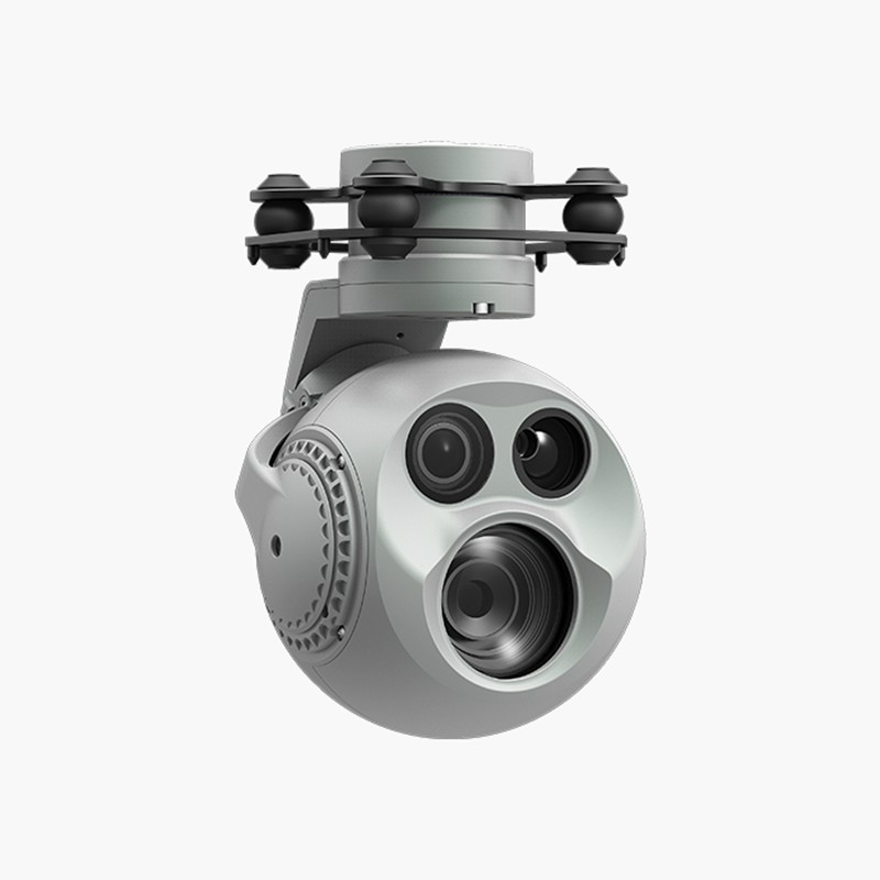
POD DC-03 оснащен высокоостным неортогональным шарниром с тремя осевыми и оборудована широкоугольной и 30-кратной гибридной камерой масштабирования. После поиска целевого объекта в широкоугольном изображении он может быстро переключиться на изображение Zoom для подробного наблюдения. POD также оснащен лазерным дальномером, который может обеспечить координаты расстояния и положения цели наблюдения, помогать в быстрого и точном позиционировании и повысить эффективность работы,POD DC-03 обладает AL-многоцелевым обнаружением и отслеживанием AL. Струйт может разумно распознавать пешеходов и транспортных средств на захваченном изображении и постоянно блокировать и отслеживать любую цель. POD DC-03 поддерживает как прямое, так и обратное установку и может быть быстро установлен на различных беспилотных летательных аппаратах или других платформах-носителях без необходимости в инструментах. В сочетании с программным обеспечением GCU и Dragonfly Display и Control, он может отображать изображения в реальном времени на компьютере и управлять стручкой, поддерживая фотографию и запись видео.
Подробности
Этот Система датчиков беспилотников с несколькими газами обеспечивает БПЛА мониторинга качества воздуха в реальном времени Возможности, интегрируя более 100+ Заменяемые датчики Чтобы обнаружить CO2, PM2,5, ЛОС и токсичные газы, такие как H2S. Спроектирован для Детектор промышленного вокала Приложения и проверки соответствия окружающей среде, его двухмодовая передача 4G/Wi-Fi обеспечивает мгновенные карты загрязнения на наземные станции. А Автономный регистратор атмосферных данных поддерживает китайские/английские интерфейсы, включив Беспроводное отображение беспроводных дрон Через фабрики, свалки и зоны бедствий. С тепловыми картами траектории полета и сравнением исторических данных, это окончательное Двойной инструмент экологического обследования Для команд промышленной безопасности и инспекторов EPA.
Подробности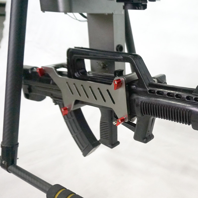
В современных быстро развивающихся технологиях военная техника также постоянно совершенствуется. Инновационное оборудование пушки Type 95, установленной на дроне, подобно новой яркой звезде, ярко сияющей на современной военной сцене.
Подробности
Разработано для высокоточные удары и быстрое развертывание на поле боя, наш Высокоточная управляемая минометная установка, устанавливаемая на беспилотник доставляет Точность 3-метровой цели в пределах Дальность управления 5 км, идеально подходит для тактических миссий и реагирования на чрезвычайные ситуации. Изучите расширенные характеристики и боевые возможности ниже.
Подробности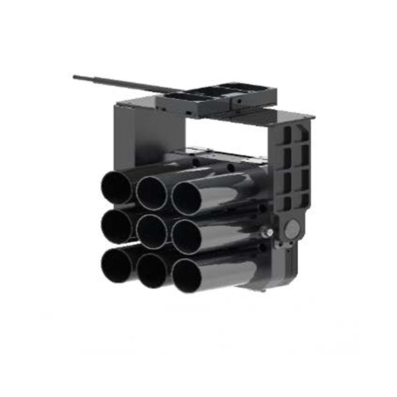
Разработанные для точности и скорости, наши Многоцелевой быстроразвертываемый беспилотный гранатомет с дымовой гранатой доставляет высотное тактическое дымовое развертывание с 38-мм многосценарная адаптируемость, идеально подходит для антитеррористических и чрезвычайных операций. Ознакомьтесь с расширенными характеристиками и готовыми к выполнению задач функциями ниже.
Подробности
Четырехсветовой модуль LQ-4 объединяет тепловизионные, зум-модули, лазерную локацию и широкоугольные модули, обеспечивая точное обнаружение в любую погоду за счет совместной работы с данными из нескольких источников. Оснащен высокоразрешающей тепловизионной системой и функцией измерения расстояний на больших расстояниях в сочетании с гибридным зумом с высоким увеличением и технологией оптического зума с высоким увеличением, в сочетании с крупногабаритными светочувствительными элементами для поддержки записи изображений сверхвысокой четкости и широкоугольным объективом высокой четкости для расширения поля зрения. Встроенная интеллектуальная алгоритмическая платформа обеспечивает возможность динамического отслеживания цели на основе глубокого обучения, а конструкция глобального вращения оси направления адаптируется к сложным требованиям к рабочему углу. Оптимизация структуры амортизации и модульного интерфейса значительно улучшает адаптивность к окружающей среде, поддерживая расширение и интеграцию нескольких устройств. Благодаря высокоэффективным алгоритмам совместного управления и стабильным системам карданного подвеса он может поддерживать четкое изображение и точное управление в динамических сценах и может широко применяться для требований к монтажу профессионального уровня в таких областях, как винтокрылые самолеты, платформы вертикального взлета и посадки и интеллектуальные мобильные роботы. Эта система лазерного дальномера с высоким разрешением тепловизионного изображения объединяет четыре усовершенствованных датчика для обеспечения всепогодного восприятия окружающей среды для дронов и роботов. Благодаря динамическому отслеживанию и сверхвысокой четкости изображения она обеспечивает критически важную четкость при пожароспасательных работах, картировании местности и промышленных проверках.
Подробности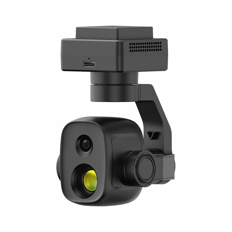
Двойной световой модуль использует совместную конструкцию двойного зондирования видимого света/тепловизионного изображения с легкой конструкцией, улучшающей многомерное восприятие дрона. Тепловизионный модуль оснащен датчиками высокого разрешения и телеобъективами, поддерживающими бесконтактное измерение температуры и идентификацию аномальных источников тепла. Интеллектуальные алгоритмы обеспечивают непрерывное отслеживание цели и быструю повторную блокировку, в то время как синхронное масштабирование/сшивание двух объективов повышает эффективность информации. Датчики изображения высокой четкости в сочетании с технологией динамической регулировки оптимизируют качество изображения, а поворотный наклон с большим углом обеспечивает панорамное наблюдение, адаптируясь к требованиям сложной сцены.
Подробности


 IPv6 network supported |
Карта сайта
|
Xml
|
блог
|
политика конфиденциальности
|
Новости
IPv6 network supported |
Карта сайта
|
Xml
|
блог
|
политика конфиденциальности
|
Новости
Наши часы
Пн 11/21 - Ср. 11/23: 9 утра - 8 вечера
Чт 11/24: Закрыт - С Днем Благодарения!
Пт 11/25: 8 утра - 22:00
Сб 11/26 - Солнце 11/27: 10 утра - 9 вечера
(Все часы восточное время)